ADVANCED FLIGHT TECHNOLOGIES
MAINTAINING VLOS: MORE THAN MEETS THE EYE
By Patrick Sherman
lucidity@roswellflighttestcrew.com

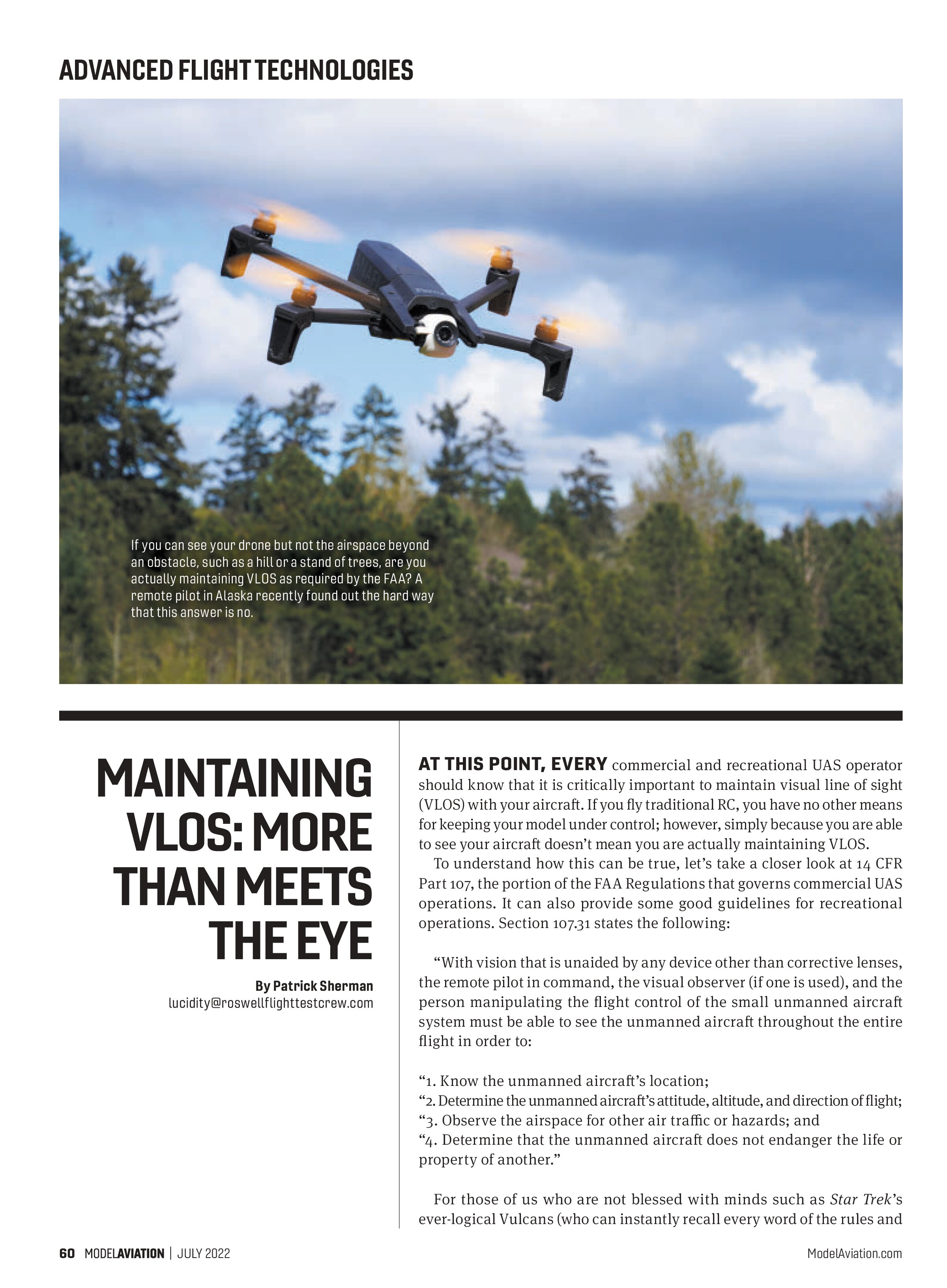
AT THIS POINT, EVERY commercial and recreational UAS operator should know that it is critically important to maintain visual line of sight (VLOS) with your aircraft. If you fly traditional RC, you have no other means for keeping your model under control; however, simply because you are able to see your aircraft doesn’t mean you are actually maintaining VLOS.
To understand how this can be true, let’s take a closer look at 14 CFR Part 107, the portion of the FAA Regulations that governs commercial UAS operations. It can also provide some good guidelines for recreational operations. Section 107.31 states the following:
“With vision that is unaided by any device other than corrective lenses, the remote pilot in command, the visual observer (if one is used), and the person manipulating the flight control of the small unmanned aircraft system must be able to see the unmanned aircraft throughout the entire flight in order to:
- Know the unmanned aircraft’s location;
- Determine the unmanned aircraft’s attitude, altitude, and direction of flight;
- Observe the airspace for other air traffic or hazards; and
- Determine that the unmanned aircraft does not endanger the life or property of another.”
For those of us who are not blessed with minds such as Star Trek’s ever-logical Vulcans (who can instantly recall every word of the rules and regulations verbatim), FAA Safety Analyst John Meehan produced a helpful acronym to remember the key points: LAADON, which stands for:
- Location: The position of the aircraft relative to its pilot, including distance and direction.
- Altitude: The elevation of the aircraft above the surface of the earth at its current location, as opposed to the surface where it was launched (which is what virtually all small UAS [sUAS] telemetry reports).
- Attitude: The aircraft orientation in the pitch, roll, and yaw axes.
- Direction of flight: The aircraft’s current heading and anticipated movement through the air.
- Observe airspace: Keep watch for other aircraft or hazards in the vicinity of the operation.
- Not pose a hazard: Ensure that the aircraft does not endanger people or vulnerable property not directly involved in the operation.
Meeting these standards requires more than seeing your aircraft. It requires you to understand what you cannot see.
The Last Frontier
This lesson was brought home painfully by Dave Russell, an aviation analyst with Robust Analytics. He recounted the story of a recent collision between an sUAS and a conventional helicopter at a popular tourist site in Alaska, which illustrated the critical importance of this type of understanding.
In this instance, the UAS pilot—who was neither certified under Part 107 nor operating within the safety programming of a community-based organization, such as an AMA—was nevertheless operating in what appeared at first glance to be a relatively safe manner, flying a DJI Air 2S below 100 feet above ground level (AGL) while capturing aerial video of tourists riding quad bikes from an appropriate distance. The aircraft was registered with the FAA.
From the remote pilot’s point of view, what happened next was terrifyingly abrupt and entirely unpredictable. A helicopter suddenly appeared over a nearby rise and collided with his drone, destroying it, then continued on its way as though nothing had happened.
Not fully appreciating the gravity of what had just occurred, nor understanding that UAS must always and forever yield the right-of-way to crewed aircraft, the remote pilot telephoned authorities to complain. He went as far as to demand that the helicopter operator pay to replace his drone, asserting that the helicopter was flying “too fast” and “too low.”
As experienced UAS pilots, we might chuckle at this individual’s naivete, while cringing at the repercussions that we know are sure to follow from the FAA, but I think that this reaction is at least somewhat comprehensible from a person with absolutely zero aeronautical knowledge.
The helicopter was operating well within the standards established by 14 CFR Part 91, specifically 91.119: Minimum Safe Altitudes, which states that helicopters are allowed to operate over rural areas below the general 500-foot AGL floor established for most crewed aircraft, provided that the pilot complies with prescribed route or altitude guidance from the FAA.
Whirlybird
The helicopter pilot, who did not exactly cover himself in glory throughout this whole episode (in my estimation), offers an interesting perspective on this same event. He acknowledged flying extremely low over the location of the incident, both to thrill his tourist passengers but also in the hopes of recruiting future passengers from among the quad bikers he knew to frequent the area.
After cresting a low rise, he reported hearing a distinct “thud,” but aircraft performance remained normal, so he continued the flight. He did land a short while later to allow his passengers to explore the surface of a glacier and took the opportunity to inspect the aircraft. Finding no sign of an impact, he continued the tour as usual. Back at the airfield, significant damage to one of the helicopter’s main rotor blades was found and the aircraft was immediately taken out of service until repairs could be made.
Because it is black-letter law that UAS must always yield the right of way to crewed aircraft, the FAA found that the drone pilot was at fault. Although intended as a recreational operation and strictly for his own personal enjoyment, the agency determined that because the pilot was not in compliance with §44809, the operation fell under Part 107 by default.
Two causal factors were identified. The UAS pilot failed to yield the right of way, and the helicopter was flying at an


extremely low altitude. However, the FAA ruled that the UAS pilot was not operating in a reckless manner and the only compliance action that was required was remedial training. In spite of the agency’s relative lenience, the pilot swore off drones forever based upon his experience.
Lessons Learned
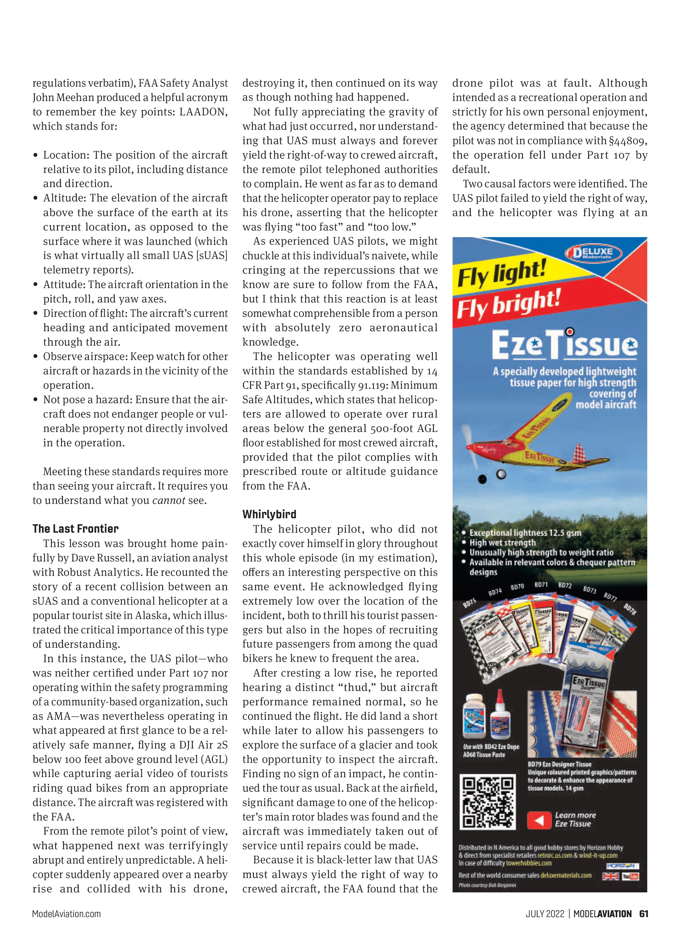
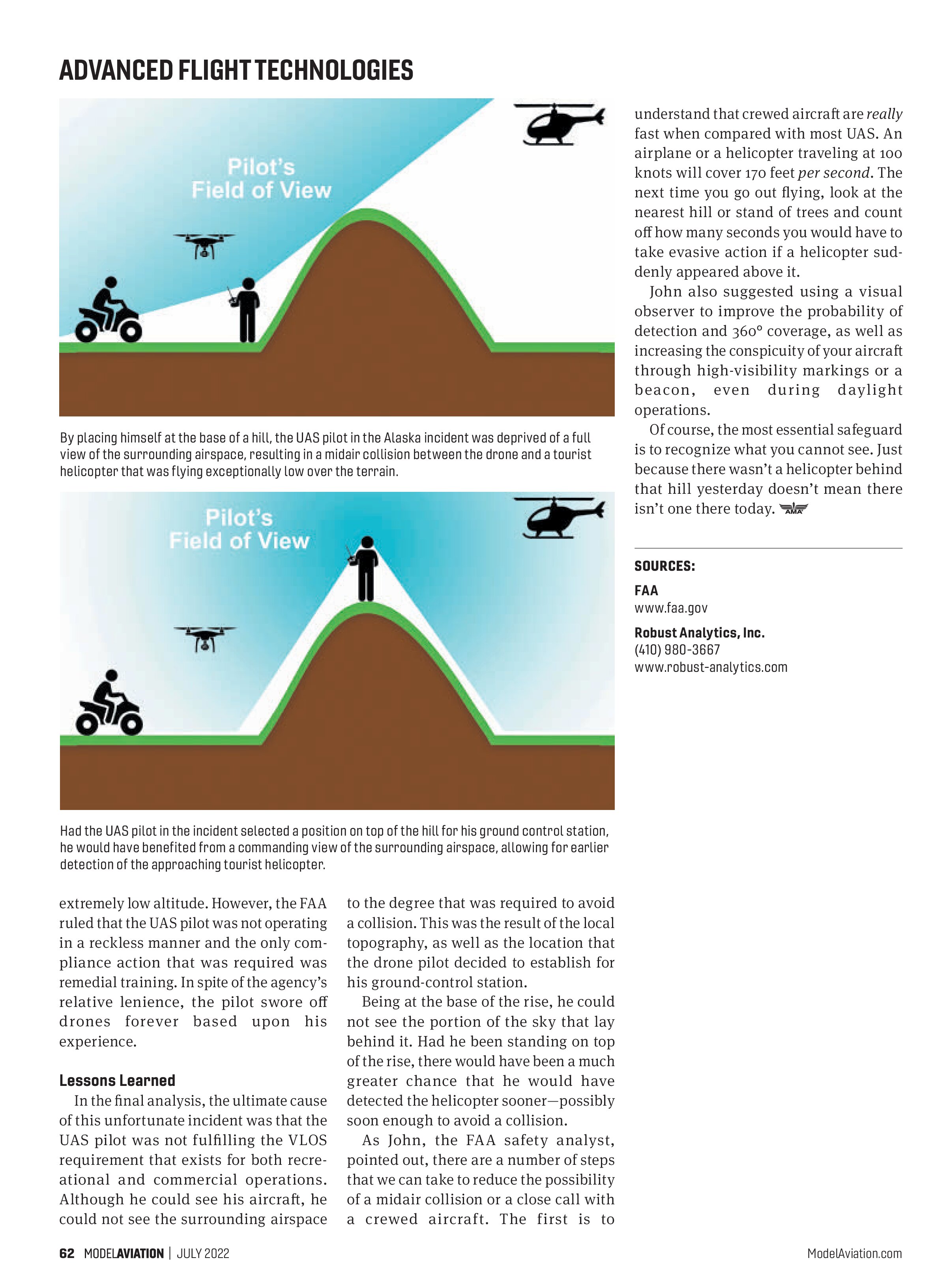
In the final analysis, the ultimate cause of this unfortunate incident was that the UAS pilot was not fulfilling the VLOS requirement that exists for both recreational and commercial operations. Although he could see his aircraft, he could not see the surrounding airspace to the degree that was required to avoid a collision. This was the result of the local topography, as well as the location that the drone pilot decided to establish for his ground-control station.
Being at the base of the rise, he could not see the portion of the sky that lay behind it. Had he been standing on top of the rise, there would have been a much greater chance that he would have detected the helicopter sooner—possibly soon enough to avoid a collision.
As John, the FAA safety analyst, pointed out, there are a number of steps that we can take to reduce the possibility of a midair collision or a close call with a crewed aircraft. The first is to understand that crewed aircraft are really fast when compared with most UAS. An airplane or a helicopter traveling at 100 knots will cover 170 feet per second. The next time you go out flying, look at the nearest hill or stand of trees and count off how many seconds you would have to take evasive action if a helicopter suddenly appeared above it.
John also suggested using a visual observer to improve the probability of detection and 360° coverage, as well as increasing the conspicuity of your aircraft through high-visibility markings or a beacon, even during daylight operations.
Of course, the most essential safeguard is to recognize what you cannot see. Just because there wasn’t a helicopter behind that hill yesterday doesn’t mean there isn’t one there today.
SOURCES:
FAA
www.faa.gov
Robust Analytics, Inc.
(410) 980-3667
www.robust-analytics.com