District I—Connecticut, Maine, Massachusetts, New Hampshire, Rhode Island, Vermont
Andy Argenio
Vice President

brandshobby@gmail.com
3 Sheila Ln., Smithfield RI 02917
Tel.: (401) 231-6901; www.amadistrict-i.org
AMA clubs and members should be prepared to answer questions and provide documentation to law enforcement, FAA agents, and other government officials indicating that UAS/model aircraft flying is in compliance with FAA regulations, state, and local laws.
Last year, we had an increase in the number of flying activities that were stopped after alleged unlawful model aircraft flying was reported to police and the FAA, by local citizens, and pilots flying manned aircraft. Nearly all of these incidents turned out to be lawful flights by AMA members operating in accordance with AMA’s safety programming.
AMA pilots should have their AMA membership card, FAA registration paper, a copy of the FAA letter permitting AMA members to fly above 400 feet, a flight location permission letter (if required), airport notification confirmed when within 5 miles of an airport, a copy of Public Law 112-95 (c) Sec. 336, and any special precautions they take when flying UAS/model aircraft.
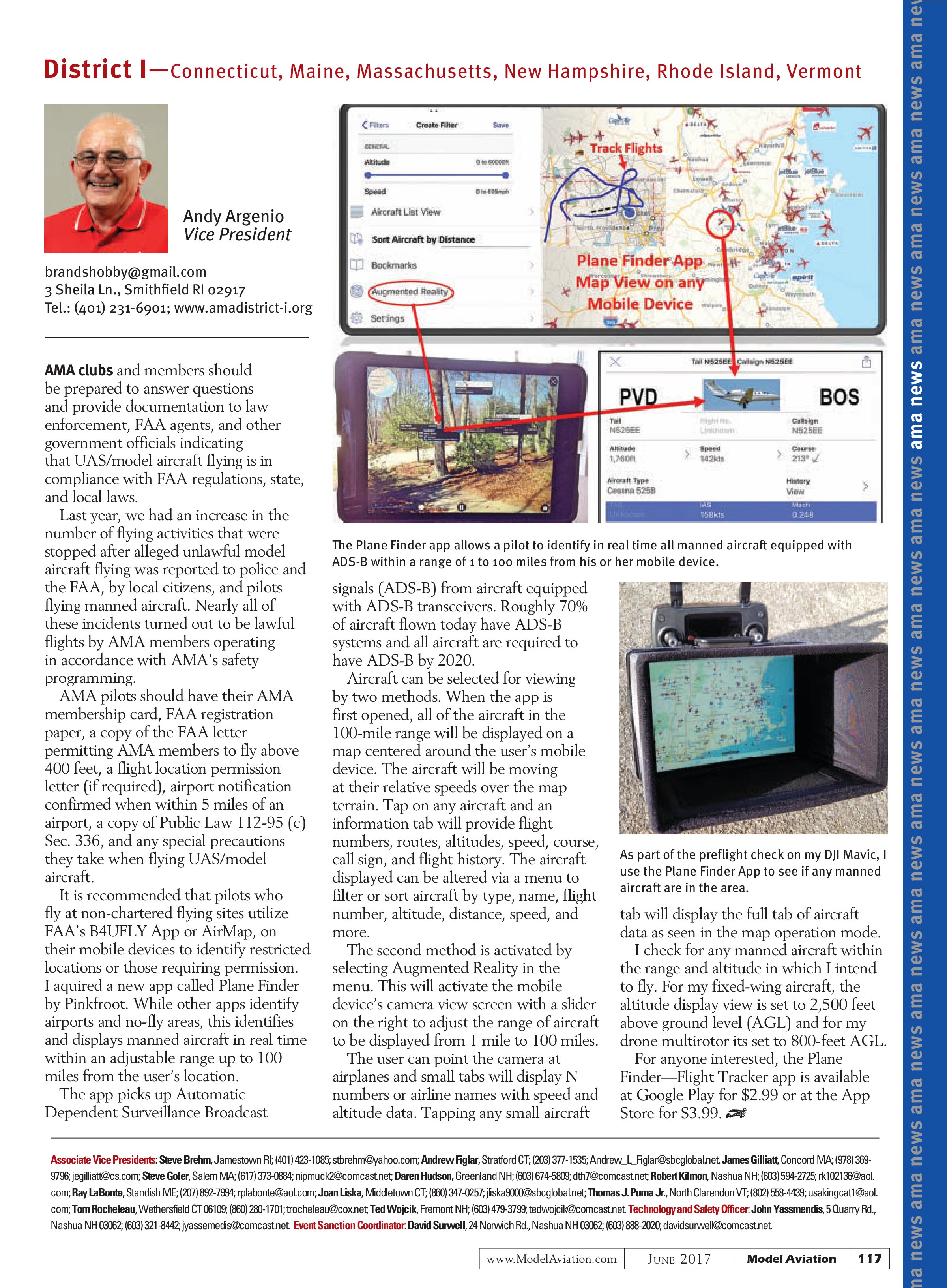
It is recommended that pilots who fly at non-chartered flying sites utilize FAA’s B4UFLY App or AirMap, on their mobile devices to identify restricted locations or those requiring permission. I acquired a new app called Plane Finder by Pinkfroot. While other apps identify airports and no-fly areas, this identifies and displays manned aircraft in real time within an adjustable range up to 100 miles from the user’s location.
The app picks up Automatic Dependent Surveillance Broadcast signals (ADS-B) from aircraft equipped with ADS-B transceivers. Roughly 70% of aircraft flown today have ADS-B systems and all aircraft are required to have ADS-B by 2020.

Aircraft can be selected for viewing by two methods. When the app is first opened, all of the aircraft in the 100-mile range will be displayed on a map centered around the user’s mobile device. The aircraft will be moving at their relative speeds over the map terrain. Tap on any aircraft and an information tab will provide flight numbers, routes, altitudes, speed, course, call sign, and flight history. The aircraft displayed can be altered via a menu to filter or sort aircraft by type, name, flight number, altitude, distance, speed, and more.
The second method is activated by selecting Augmented Reality in the menu. This will activate the mobile device’s camera view screen with a slider on the right to adjust the range of aircraft to be displayed from 1 mile to 100 miles. The user can point the camera at airplanes and small tabs will display N numbers or airline names with speed and altitude data. Tapping any small aircraft

tab will display the full tab of aircraft data as seen in the map operation mode.
I check for any manned aircraft within the range and altitude in which I intend to fly. For my fixed-wing aircraft, the altitude display view is set to 2,500 feet above ground level (AGL) and for my drone multirotor its set to 800-feet AGL.
For anyone interested, the Plane Finder—Flight Tracker app is available at Google Play for $2.99 or at the App Store for $3.99.
Associate Vice Presidents: Steve Brehm, Jamestown RI; (401) 423-1085; stbrehm@yahoo.com; Andrew Figlar, Stratford CT; (203) 377-1535; Andrew_L_Figlar@sbcglobal.net. James Gilliatt, Concord MA; (978) 369-9796; jegilliatt@cs.com; Steve Goler, Salem MA; (617) 373-0884; nipmuck2@comcast.net; Daren Hudson, Greenland NH; (603) 674-5809; dth7@comcast.net; Robert Kilmon, Nashua NH; (603) 594-2725; rk102136@aol.com; Ray LaBonte, Standish ME; (207) 892-7994; rlabonte@aol.com; Joan Liska, Middletown CT; (860) 347-0257; jlis ka9000@sbcglobal.net; Thomas J. Puma Jr., North Clarendon VT; (802) 558-4439; usakingcat1@aol.com; Tom Rocheleau, Wethersfield CT 06109; (860) 280-1701; trocheleau@cox.net; Ted Wojcik, Fremont NH; (603) 479-3799; tedwojcik@comcast.net. Technology and Safety Officer: John Yassmendis, 5 Quarry Rd., Nashua NH 03062; (603) 321-8442; jyassemedis@comcast.net. Event Sanction Coordinator: David Surwell, 24 Norwich Rd., Nashua NH 03062; (603) 888-2020; davidsurwell@comcast.net